Gallinas Creek Letters: Page 2
Link back to Letters Page 1
Proposed Recreation Facility at San Rafael AirportComments for San Rafael February 28 Planning Commission MeetingContents
Contents.............................................................. 2 Summary Conclusions................................................... 3 Noise Summary...................................................... 3 Traffic Summary.................................................... 3 Biotic Summary..................................................... 3 Aviation Summary................................................... 3 Flood Hazard Summary............................................... 4 Access from Soccer fields at McInnis Park is Dangerous and Perils Wetlands 4 Aesthetics......................................................... 4 Noise Element Mitigations are Inadequate.............................. 5 Noise Discussion.................................................... 5 Noise Deficiencies.................................................. 5 Traffic Study Discussion.............................................. 6 Traffic Study Deficiencies.......................................... 6 Comprehensive Estimates of Real Traffic Impact..................... 7 Traffic Study Conclusions........................................... 8 Biotic Study.......................................................... 9 Biotic Mitigation Deficiencies...................................... 9 Aviation and Ground Safety at Proposed Site.......................... 10 Ground and Aviation Safety Discussion.............................. 10 Aviation and Ground Safety Mitigation Deficiencies................. 10 Aviation Accidents are Common at San Rafael Airport................ 11 Airplane Hits Maintenance Worker.................................. 11 Two Airplane Collisions........................................... 12 Airplane Stalls on Takeoff........................................ 12 Airplane Collision with Fence..................................... 12 Forced Landing Collision.......................................... 13 Crash Landing at McInnis Park..................................... 13 Likely Construction Damage to Neighboring Properties................. 14 Deficiencies with Proposed Construction Mitigation Discussion...... 14 Flood Hazards........................................................ 15 Proposed Change in Floodproofing Mitigation........................ 15 Dry Flood-proofing vs. Wet Flood-Proofing Discussion............... 15 Appropriateness of Floodproofing.................................. 16 Airport Flood Photos............................................... 18 Flood Hazard Conclusions.......................................... 19 Alternative Access is Unsafe and Impacts Wetlands.................... 20 Aesthetics........................................................... 23
Summary Conclusions
The San Rafael Planning Commission and the City Council can not approve this project without additional studies including an EIR. Unkown changes to the project make prohibit a complete public examination of the project Noise SummaryThe Noise study entirely neglects to address the impact of intermittent noise that will be created by the stated use of this facility. These intermittent noises are in direct conflict with San Rafael’s Noise Ordinance section 8.13.030B, Traffic SummaryThe Neg Dec’s failure to account for daytime use of the facility contradicts arguments advanced by the project proponents that this project will reduce the problems that this facility is proposed to solve, namely the lack of facilities for youth and adult games, practice and training. Mitigation Measure XVa.1[1] substantially underestimates traffic mitigation fees for AM and PM. trip generation that would result from construction and use of the proposed sports facility.
The Fehr & Peers Traffic Study considers a 70,000 square foot facility, although the square footage of the proposed building has since increased by over 22% to 85,700 square feet. The Traffic Study does not take into account the viewing, café, sports shop, and meeting room’s uses specified in the application and description.
Closed hours on these fields during after school hours and evenings will turn into public demand and create a financial incentive for the facility operator to seek additional hours shortly after the proposed facility is built. This inevitable request for additional hours will cause Peak AM trips and Peak PM trips that have not been accounted for with recommended mitigations. Biotic SummaryThe habitat of the California Clapper Rail will be substantially degraded by construction and use of this facility. The NegDec has not taken into account the impact on this and other species in close proximity to the proposed facility. Since only the site was evaluated, the total environmental footprint of the project has not been considered. Aviation SummaryGround Safety has not been analyzed in relation to the building, therefore this is an unmitigated hazard. Further, errant baseballs may create a hazard for aircraft n approach, takeoff and while maneuvering on the ground.
Construction Summary The seismic impact to wildlife adjacent to the site from pile driving and other construction activity has been entirely ignored in the NegDec. Supporting studies suggest that cosmetic damage may occur to adjacent neighbors, however the claim that these damages will be limited to cosmetic are unsubstantiated. Changes to construction plans and engineering due to the change to dry floodproofing from wet flood-proofing are not available for examination. Flood Hazard SummaryMinimally the NegDec must be re-circulated because of significant project revisions that will be required to comply with new dry floodproofing mitigations. In fact, the project application may need to be resubmitted because the building will now need to be radically redesigned.
Regardless of any changes to the project, plans, or studies, Staff contends that Dry Floodproofing is a “more restrictive measure” than wet-Fgoodproofing. However there is no substantiation for this statement in San Rafael’s Municipal Codes or FEMA regulations.
Wet and dry floodproofing are merely different mitigations for different applications. And dry floodprooing is not more stringent than wet floodproofing. Further, since Wet floodproofing was not an appropriate mitigation for this project, this is the first exposure the public has had to a mitigation measure for building below the base flood elevation. Therefore, the public and other interested parties have not had the required 30 days to comment on all mitigations.
Finally, dry floodproofing is not appropriate for this facility because of past flooding and the potential difficulties of evacuation and potential for hazards to life and property.
Any resolution for the adoption of the Initial Study/Mitagated Negative Declaration Use Permit or Zoning changes are contingent on the floodproofing and are not appropriate for consideration at this point. Access from Soccer fields at McInnis Park is Dangerous and Perils WetlandsAccess to the closest Soccer field at McInnis Park to the Airport Facility will be over an unfenced, railroad bridge that is in a state of disrepair, not intened for pedestrians and hazardous. This “shortcut” tempts users to cross sensitive wetlands. The shortcut is over a hazardous railroad bridge not designed for pedestrians. AestheticsDesign Review has failed to address significant public views that will be impacted by this project. Specifically, views from a public waterway, along the North and South Forks of Gallinas Creek will be impacted. The project is adjacent to the North Fork of Gallinas Creek which is serviced by a public boat launch at McInnis Park immediately across the creek from the building site.
Since elevation of the creek is below the levee trail, users of the creek have entirely different line of ridgelines and other natural and manmade features in the environment. Views from the creek have not been considered by design review. Since the Design Review Process did not consider these views and therefore the aesthetic review is inadequate.
Noise Element Mitigations are Inadequate Noise DiscussionThe Noise study entirely neglects to address the impact of intermittent noise that will be created by the stated use of this facility. These intermittent noises are in direct conflict with San Rafael’s Noise Ordinance section 8.13.030B:
No person shall produce, suffer or allow to be produced by any machine, animal, or device, or by any other means, a noise level greater than sixty-five (65) dBA intermittent or fifty-five (55) dBA constant, when measured on any commercial property.
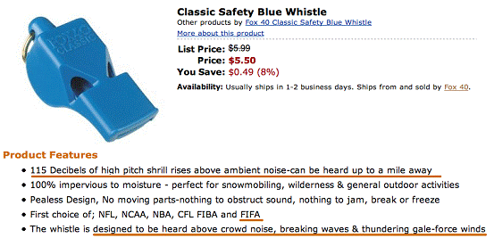
Sports whistles, by design create intermittent noises far in excess of 65dBA so they can be heard above the noise of play and crowds. Each soccer game would have at least one and as many as three referees and/or coaches equipped with whistles for each practice or tournament. Whistles are blown at specific intervals during each game and may be blown an infinite number of times during any one game for rule infractions and fouls. Whistles are commonly used in other indoor and outdoor field games. Noise DeficienciesResidents in Captains Cove, Contempo Marin and Santa Venetia can already hear whistles and crowd noise from the outdoor fields at nearby McInnis Park. Adding another indoor and outdoor soccer field only increases this nuisance. The NegDec does not take this into account.
The impact of intermittent noise on wildlife within the one-mile radius that soccer whistles can be heard has also been ignored in the NegDec.
The Fehr & Peers Traffic Study considers a 70,000 square foot facility, although the square footage of the proposed building has since increased by over 22% to 85,700 square feet. The Traffic Study does not take into account the viewing, café, sports shop, and meeting room’s uses specified in the application and description.
The Traffic Study calls for zero AM peak traffic trips and two PM peak traffic trips to the Soccer Complex based on the first league games beginning at 6:20 PM.[3] The project description indicates that the “soccer facility is proposed to operate from 9:00 AM to 11:00 PM”
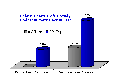
Subsequent NegDec Supporting Documents rely upon and reflect the faulty conclusions of the Fehr & Peer study and therefore are inaccurate. In particular, the City Traffic Engineer’s analysis on pages 81-83 of the NegDec needs revision. Traffic Study DeficienciesFehr & Peers estimates that there will be 104 PM peak hour trips and no AM peak hour trips. [4]
The traffic study contains numerous errors of omission. In regards to Peak AM trips (7:00-9:00 a.m.) zero trips are projected even though the facility will open at 9:00 a.m. At least one person will need to unlock the doors, and if the facility is to open at 9:00 am the assumption must be that that there will be at least some users of the facility. AM use is particularly likely during the summer. Since there is no public transportation to the facility so there will clearly be some peak AM trips.
The soccer portion of the facility will be open from 9:00 AM to 11:00 PM Sunday through Thursday and from 9:00 AM to midnight on Friday and Saturday. However the Traffic Analysis is based solely on league games with the earliest start at 6:20 p.m. The traffic study specifies no users of the Soccer Facility between 9:00 a.m. and 6:20 p.m. Again, if the facility is open, there will be at least some users of the facility and those arriving between 4:00 and 6:00 PM will be traveling at the peak hour and only two trips for employees are accounted for in the traffic study. It should be noted that it is difficult to make any trip from Southern Marin to Smith Ranch Road in less than twenty minutes, so it is unlikely that users arriving for a 6:20 PM start will not be on the road before 6:00 PM>
The Traffic Study is problematic in that it suggests there will be no Soccer Facility users at the facility before 6:20 p.m. The Traffic study also indicates that the outdoor baseball field will be open only on weekends.
During summer and School recesses, the demand for these soccer facilities to be open for practice, training and/or games during the entire day will be greater. There will also be demand for games at the outdoor baseball field year round and particularly during weekday summer evenings.
Closed hours on these fields during after school hours and evenings will turn into public demand and create a financial incentive for the facility operator to seek additional hours shortly after the proposed facility is built. This inevitable request for additional hours will cause Peak AM trips and Peak PM trips that have not been accounted for with recommended mitigations.
The charts and table on the following page illustrate the true traffic that will be generated.
Comprehensive Estimates of Real Traffic Impact
Table ATraffic Forecasts with Events Scheduled During Stated Operating Hours
AM Comprehensive Forecast includes Fehr & Peers estimates plus the addition of one baseball/softball event with 18 players, two coaches and one umpire and three observers and or users of the café/meeting rooms for a 9:00 am start. Also included are two staffers to unlock doors. AM Soccer uses are one 9:00 am start on two indoors fields and one 9:00 am start on outdoor field.
PM Comprehensive Forecast includes Fehr&Peers estimates plus the addition of two games or practices each on each of the two indoor and one outdoor soccer field from 4:00 to 6:00 p.m. and 12 mezzanine observers and six non player/or observers at café and/or meeting rooms. Table B
|
|||||||||||||||||||||||||||||||||||||||||||||||||||||||||||||||||||||||||||||||||||
| Use |
Automobile Trips |
| Indoor Soccer Event |
16 |
| Outdoor Soccer Event |
28 |
| Café, Meeting Rooms and Viewing Areas |
Not considered by FEHR & Peers |
Traffic Study Conclusions
The Neg Dec’s failure to account for daytime use of the facility contradicts arguments advanced by the project proponents that this project will reduce the problems that this facility is proposed to solve, namely the lack of facilities for youth and adult games, practice and training. Mitigation Measure XVa.1[5] substantially underestimates traffic mitigation fees for AM and PM. trip generation that would result from construction and use of the proposed sports facility.
The Staff Report[6] released on February 17 attempts to explain that the 104 trips with a gymnastics tenant represent “the most intense combination of recreational uses” with a mitigation for 104 peak PM. trips with zero AM trips. In fact, since all of the uses of the facility as described in the project plan have not been included, the traffic study is flawed. AM trips have been ignored entirely and PM peak trips are underestimated by 165%.
Biotic Study
The Biotic Study only takes into account the direct footprint of the proposed parking lot and soccer facility. No upstream or downstream studies have been made nor has the impact of construction on wildlife and protected species been considered.
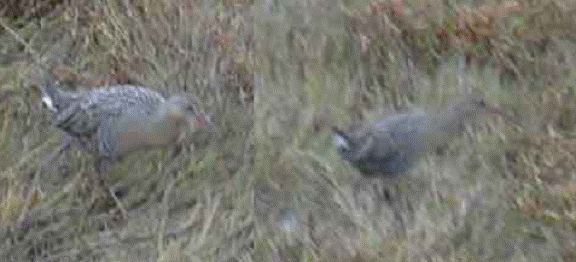
Attached are two photographs of a California Clapper Rail photographed on December 20, 2004 behind the 200 block of Vendola Drive on the South Fork of Gallinas Creek at approximately 4:00 PM. This location is approximately 1400 feet from where piles will be driven for the proposed building’s foundation and approximately 1200 feet from the parking lot.
Biotic Mitigation Deficiencies
The habitat of the California Clapper Rail will be substantially degraded by construction and use of this facility. The NegDec has not taken into account the impact on this and other species in close proximity to the proposed facility. Since only the site was evaluated, the total environmental footprint of the project has not been considered.
I concur with the findings and recommendations of the Marin Audubon Society in regards to potential and real impacts to wildlife and wildlife habitat.
Clapper Rail in Marsh at South Fork of Gallinas Creek. 1,400 Feet from site.
|
|
|
|
|
Aviation and Ground Safety at Proposed Site
Ground and Aviation Safety Discussion
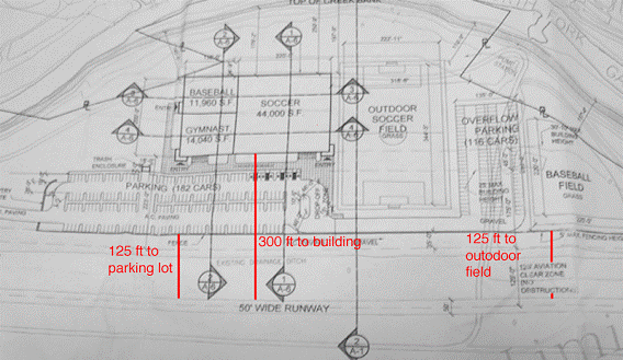
There is no discussion of Ground Safety for the people on the ground. The 125 foot clear zone and 1:7 foot maximum rise for structure, landscaping and other architectural features including fences is designed for the safety of aviators and their passengers, and not for people on the ground.
In addition to the obvious hazard created by the main building which will be 41 feet above grade[7] at its tallest point, the outdoor parking lot, soccer field and baseball field are of serious concerns. The parking lot is only 125 feet from the runway and the 36 (average) foot tall, 85,000 square foot building is proposed for 300 feet from the runway.
The February 13 staff report notes:
“the story poles were installed ten feet closer to the northern property lines than the plans indicated.”[8]
It is strongly advised that the City of San Rafael staff verify actual site measurements rather than rely on plans in regards to the location of all elevations of the proposed project to insure they conform to the 1:7 clear zone and other applicable concerns for safety.
The outdoor fields are as close as 125 feet of the runway. Only a five-foot fence shields the parking lot and right side of the baseball field from the runway. And at one point a movable 35-foot backstop was proposed to alleviate foul balls. A movable backstop higher than five feet would clearly violate the 1:7 foot aviation clear zone. Storage of this movable backstop is also unanswered.
Aviation and Ground Safety Mitigation Deficiencies
An unmitigated hazard inherent to the use proposed will be errant baseballs and soccer balls. It will not be uncommon for baseballs to be batted toward the runway along the right “foul” line. Since the fence on the right foul line is only five feet high, virtually all foul balls on the right side and some from behind home plate will end up near, on or across the runway, which is only 125 feet from the fence. There will be temptation to retrieve these balls by participants, which would create danger to their own safety and that of aircraft. “Fly” foul balls will also create a hazard for aviation with the possibility that an errant ball might strike an airplane on approach, landing or while maneuvering on the ground. When a soccer ball is kicked over the parking lot or fence, similar hazards will be created. While the soccer field is further away, users of the facility might kick soccer balls in “pick-up” games while in the parking lot.
The diagram and table on the following page shows the dangerous proximity to an active runway for the proposed uses. Summaries of recent aviation accidents are also included.
Site Plan Showing Proximity to Active Runway |
|
|
Aviation Accidents are Common at San Rafael Airport
There have been six flight related incidents at the San Rafael Airport from 1983 to 2004. Five of these accidents (83%) were on weekends, when the proposed Sports complex would be the busiest. There has been a serious aviation accident every 3.66 years at the San Rafael airport.[9]
Airplane Hits Maintenance Worker
Sunday, May 15, 1983, 7:30 p.m. (Upper
case format from FAA.com)
THE PLT REPORTED THAT DURING HIS FINAL APCH TO LAND,
HE OBSERVED AN INDIVIDUAL ON A SMALL LAWN-TYPE TRACTOR,
WELL CLEAR ON THE LEFT SIDE OF THE RWY. JUST AFTER TOUCHDOWN,
AS HE WAS LOWERING THE NOSE, HE OBSERVED THE TRACTOR PASS
UNDER THE LEFT WING OF THE ACFT. HE REPORTED THAT HE FELT
NO IMPACT, BUT AFTER TURNING OFF THE RWY, HE NOTED THE LEADING
EDGE OF THE WING WAS DENTED. HE NOTIFIED THE ARPT MANAGER,
WHO INSPECTED THE RWY. THE TRACTOR OPERATOR WAS FOUND LYING
ON THE LEFT SIDE OF THE RWY WITH SERIOUS HEAD INJURIES &
WAS TRANSOPORTED TO THE HOSPITAL.
Two Airplane Collisions.
Saturday, April 1986, 7:30 p.m. (Upper case format from FAA.com)
THE TWO AIRCRAFT COLLIDED ON THE RUNWAY DURING THE LANDING APPROACH. THE CESSNA PILOT HAD WASHED HIS AIRCRAFT AND HAD MADE A LOCAL FLIGHT TO DRY IT OFF. THE BEECH PILOT WAS RETURNING FROM A NEARBY AIRPORT WHERE AN ANNUAL INSPECTION HAD BEEN PERFORMED. WITNESSES STATED THAT THE CESSNA HAD LANDED AND WAS ROLLING ON THE RUNWAY WHEN THE BEECH LANDED ON TOP OF IT. EACH PILOT STATED THAT HE ANNOUNCED HIS INTENTIONS, BUT EACH PILOT STATED THAT HE DID NOT HEAR THE OTHER.
Airplane Stalls on Takeoff
Saturday, June 20, 1986, 3:00 p.m. (Upper case format from FAA.com)
THE ACFT STALLED AND COLLIDED WITH THE GROUND INITIAL DURING A TAKEOFF INITIAL CLIMB. HE INDICATED THAT HE MISJUDGED THE STALL BUFFET AS TURBULENT AIRFLOW FROM A CROSSWIND. THE RIGHT WING DROPPED AND THE ACFT STALLED. THE PLT ALSO INDICATED THE STALL WARNING DID NOT SOUND. A LOCAL SHEEPHERDER WHO WITNESSED THE ACCIDENT STATED THAT THE ACFT ATTEMPTED TO TAKEOFF DOWNWIND.
Airplane Collision with Fence
Sunday, December 6, 1986, 3:50 p.m. (Upper case format from FAA.com)
DURING AN INSTRUCTIONAL FLIGHT, THE STUDENT PILOT WAS NOT ALIGNED PROPERLY WITH THE RUNWAY. THE FLIGHT INSTRUCTOR (CFI) TOOK CONTROL OF THE AIRCRAFT ON FINAL, BUT HE STATED THAT IT DID NOT RESPOND WHEN HE APPLIED RUDDER CONTROL. AFTER TOUCHDOWN, THE AIRCRAFT SWERVED TO THE RIGHT, RAN OFF THE RUNWAY AND COLLIDED WITH A FENCE. NO MECHANICAL PROBLEM WAS FOUND WITH THE RUDDER CONTROL. THE CESSNA NAVOMATIC AUTOPILOT WAS FOUND TO BE IN THE 'ON' POSITION. IT WAS AN ELECTRIC, SINGLE-AXIS, AILERON CONTROL UNIT THAT DID NOT AFFECT RUDDER CONTROL.
Forced Landing Collision
Saturday, October 3, 2003 3:30 p.m.
The aircraft collided with the ground short of the runway while attempting a forced landing following a loss of power in the takeoff initial climb. Witnesses reported after the airplane was airborne, the airplane engine started to "sputter" and the airplane turned back towards the airport. As the airplane touched down the wing tip touched the ground and airplane cartwheeled. The pilot said that he aborted his first takeoff after an indication of low fuel pressure. The pilot taxied back and did another run up. He was unable to determine, or duplicate, the fuel pressure abnormality observed during the first takeoff roll and elected to attempt a second takeoff. During the takeoff initial climb the engine started to sputter and lost power. The pilot attempted to turn back towards the runway, but the airplane had insufficient altitude and collided with the ground short of the pavement. The last pilot to fly the accident airplane told investigators that he had refueled the airplane to capacity at a nearby airport located 26 nm northeast of this airport. He stated that when he secured the airplane in his hangar the left fuel tank was 1/3 full, and the right fuel tank was 3/4 full. He said no one had flown the airplane since. During the accident sequence the left wing separated from the fuselage and the outboard 1/3 of the right wing was folded over. The gascolator and left fuel tanks were breeched and no fuel was found. The first responders, including fire and police units, to the accident scene did not see any fuel, nor did they detect the odor of fuel. A Federal Aviation Administration (FAA) inspector responded to the accident site and examined the wreckage. The inspector was unable to locate any evidence of fuel in the remaining aircraft system components or spillage on the ground. Following recovery from the accident site, a test run of the engine was accomplished while it was still mounted in the airframe. An external fuel source was engineered to deliver fuel directly to the inlet line of the carburetor. The engine was started using the aircraft's own starter switch and engine controls. The engine started and was run up to 1,300 rpm where it was operated for approximately 1 minute, then shut down. Oil pressure during the engine operation was observed to be in the green arc, approximately 60 psi.
Crash Landing at McInnis Park
Monday, August 30, 2004 5:37 p.m.
On August 30, 2004, about 1737 Pacific daylight time, a Rockwell International 112TCA, N44MH, experienced a total loss of engine power during initial climb from a private airstrip about 3 miles north of San Rafael, California. The pilot made a forced landing in a marshy area of the McInnis Park. The airplane nosed over upon touchdown and was substantially damaged. The private pilot, who owned and operated the airplane, sustained minor shoulder harness-related restraint type injuries. Visual meteorological conditions prevailed, and no flight plan had been filed. The personal flight was performed under the provisions of 14 CFR Part 91. The flight originated from San Rafael about 1736, destined for Sonoma, California. The pilot reported to the National Transportation Safety Board investigator that he had just refueled his airplane at the San Rafael private airstrip, his home base. Thereafter, he performed a normal preflight inspection and checked the engine's magnetos. No discrepancies were noted. Full engine power was applied during the takeoff roll, with the fuel selector positioned to the "Both" tanks position. Upon climbing between 100 and 200 feet above ground level, the engine suddenly lost all power. The pilot stated that, to the best of his recollection, the power loss was not preceded by any unusual sound. The pilot made a forced landing about 1/4 mile beyond the runway's departure end. After the airplane came to rest upside down in the 2- to 4-foot-deep marsh, the pilot extricated himself and waded to the shore
Likely Construction Damage to Neighboring Properties
The project will require Driven Concrete Piles through 28 feet of Bay Mud.[10] Mitigations V1.c.1-f indicates:
Pile Driving may cause vibration that could result in cosmetic damage to adjacent properties. The owner or contractor should visit the adjacent property owners to map out the existing conditions and that vibration monitors be installed to monitor pile driving vibrations.
Deficiencies with Proposed Construction Mitigation Discussion
The seismic impact to wildlife adjacent to the site from pile driving and other construction activity has been entirely ignored in the NegDec.
Mitigation V1.c.1-f indicates the possibility of “cosmetic” damage to neighborhood structures; the supporting Geotechnical Report fails to quantify this vibration. Additionally the reporting engineer[11] has not visited the neighboring properties and therefore has no basis to substantiate the statement that limits the potential damage. It should be noted that the liquid qualities of Bay Mud, like water, amplify the seismic effects such as those produced by pile driving and therefore have the potential to cause greater than cosmetic damage to neighboring properties.[12]
The proposed mitigation provides no mechanics to compensate neighboring property owners for damage caused by the construction. Therefore, it is expected that some litigation will result from the construction of the project. This litigation is likely to involve the project property owner, contractors, neighbors and the City of San Rafael.
Flood Hazards
Proposed Change in Floodproofing Mitigation
Significant changes to the flood safety mitigations are proposed for the 85,700 square foot building, which is the most significant element of this project. The most recent Staff Report indicates that:
Although not yet finalized, a revision to the mitigation measures is currently being drafted and this change would be one of a more restrictive nature. In summary, the project would be required to be dry flood-proofed, rather than wet flood-proofed. Dry flood proofing means that the structure would be built in accordance with standards to ensure that it is impenetrable to flood waters. Once the details are of this potential revision finalized, staff will forward any proposed revisions to the mitigation measures and conditions of approval to the Commission for their consideration. Staff also notes that consistent CEQA Guidelines Section 15073.5, recirculation of a Negative Declaration prior to adoption is not required when mitigation measures are replaced with equal or more effective measures.
The same CEQA Guideline, Section 15073.5 (1) indicates that a Negative Declaration must be re-circulated when:
A new, avoidable significant effect is identified and mitigation measures or project revisions must be added in order to reduce the effect to insignificance.
Dry Flood-proofing vs. Wet Flood-Proofing Discussion
The project as planned and described is as follows:
A clear span structure and is proposed to be clad with a variety of building material, including a combination of textured metal panels along the base of the structure, vertical metal panels on the corners of the building, flush metal fascia panels, and a sloped metal roof.[13]
The building plans and most associated studies regarding the facility are based on an 85.600 square foot, clear span metal building designed for a wet flood-proofing standard. These studies include, but are not limited to: Geotechnical, Hydrological, Biological, Hazards, Noise, Aesthetics, Land Use, Traffic and Planning Studies.
A dry flood-proofed building must be made to withstand the forces of hydrostatic pressure and buoyancy. The minimum engineering requirements as set forth in FEMA Technical Bulletin 7-93 for Non-Residential Floodproofing[14]:
The Technical Bulletin states the building must be watertight (i.e., floodwaters must not enter the building envelope):
a. The building must be watertight to the floodproof design elevation, which is further defined as being at least the BFE.
The technical bulletin continues:
All of the building’s structural components must be capable of resisting specific flood-related forces. These are the forces that would exerted upon the building as a result of floodwaters reaching the BFE (at a minimum) or floodproofing design level and include the following:
a. Hydrostatic Flood Force—This is the force that water at rest exerts on any submerged object. For a floodproofed building design, the calculations of hydrostatic flood forces must include saturated soil pressure on any portion of the building that is below grade.
Since this building will need to be dry flood proofed to a Base Flood Elevation of seven feet, the hydrostatic pressure on the walls would need to be engineered to withstand 436.8 pounds per square inch per the drawing below from FEMA Technical Bulleting 7-93 There are no studies or engineers drawings in the NegDec or project file that demonstrate the building that the current design can be dry floodproofed.
Figure
C
Minimum Hydrostatic Engineering Requiments for Floodproofed
Buildings[15]

Appropriateness of Floodproofing
FEMA Bulletin 3-93 speaks on planning consideration for floodproofing in sections on Flood Warning Time, Safety and Access, Flood Velocities/Depth/Debris and Flood Frequencies.[16] These planning considerations have not been addressed in the NegDec.
The FEMA Bulletin 3-93 prescribes that:
For any floodproofed building all roads to be used as evacuation routes must remain passable as floodwaters rise. In addition, all roads that provide access to buildings whose dry floodproofing components require human intervention must remain passable long enough for the floodproofing components to be installed and for all personnel to safely evacuate the site.[17]
The Bulletin says about Flood Frequency
A site that has been flooded frequently may not be appropriate for a dry-floodproofed building.[18]
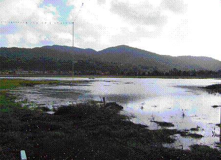
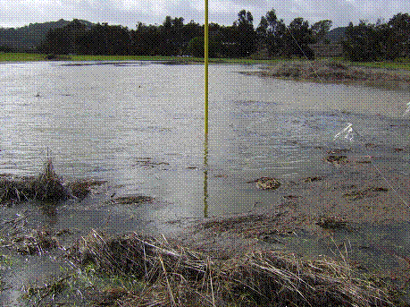
Airport Flood Photos
The building site floods regularly during storm events and high tides. The photos below show the building site in a flooded state on December 31, 2005. Additional photos are available at www.gallinascreek.org
Flood Photos: Tidal Flooding at Airport Site |
|
|
|
The proposed building site suffers from tidal flooding. |
|
|
|
Story pole for proposed building submerged in flood water. |
Flood Hazard Conclusions
Minimally the NegDec must be re-circulated because of significant project revisions that will be required to comply with new dry floodproofing mitigations. In fact, the project application may need to be resubmitted because the building will now need to be radically redesigned.
Regardless of any changes to the project, plans, or studies, Staff contends that Dry Floodproofing is a “more restrictive measure” than wet-Fgoodproofing. However there is no substantiation for this statement in San Rafael’s Municipal Codes or FEMA regulations.
Wet and dry floodproofing are merely different mitigations for different applications. And dry floodprooing is not more stringent than wet floodproofing. Further, since Wet floodproofing was not an appropriate mitigation for this project, this is the first exposure the public has had to a mitigation measure for building below the base flood elevation. Therefore, the public and other interested parties have not had the required 30 days to comment on all mitigations.
Finally, dry floodproofing is not appropriate for this facility because of past flooding and the potential difficulties of evacuation and potential for hazards to life and property.
Any resolution for the adoption of the Initial Study/Mitagated Negative Declaration Use Permit or Zoning changes are contingent on the floodproofing and are not appropriate for consideration at this point.
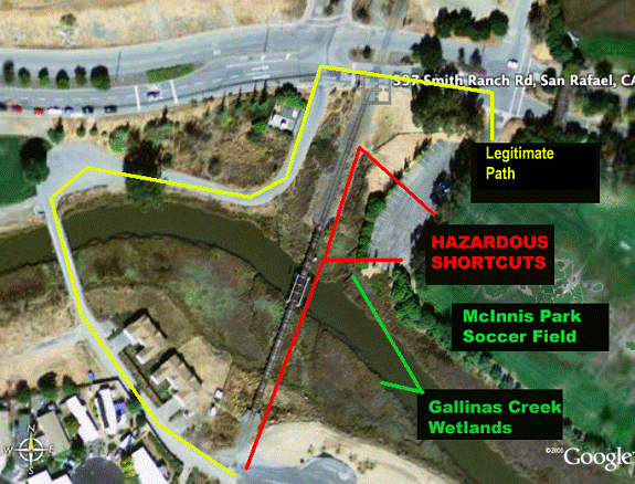
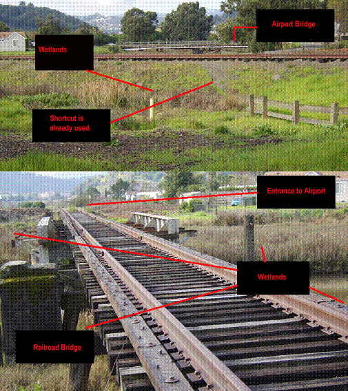
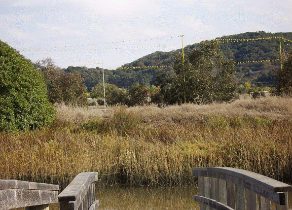
Alternative Access is Unsafe and Impacts Wetlands
Project Proponents site synergies with McInnis County Park for meeting recreation needs in the San Rafael and County General Plans. Specifically, project proponents have discussed proposals pending with the County of Marin to help finance all weather fields that would make the combination of facilities suitable for tournaments.[19] that will increase the circulation need between the facility and the soccer fields at McInnis Park.
Access to the closest Soccer field at McInnis Park to the Airport Facility will be over an unfenced, railroad bridge that is in a state of disrepair, not intened for pedestrians and hazardous.
This “shortcut” tempts users to cross sensitive wetlands. The shortcut is over a hazardous railroad bridge not designed for pedestrians.
No mitigation measures are noted in NegDec.
Signs forbidding use of the railroad bridge are currently non existiant and may be ineffective in failing to protect wetlands and people.
DANGEROUS SHORTCUTS OVER RAILROAD BRIDGE AND WETLANDS |
|
|
|
Shortcut to Airport across wetlands is known and used . |
|
|
Aesthetics
Design Review has failed to address significant public views that will be impacted by this project. Specifically, views from a public waterway, along the North and South Forks of Gallinas Creek will be impacted. The project is adjacent to the North Fork of Gallinas Creek which is serviced by a public boat launch at McInnis Park immediately across the creek from the building site.
Since elevation of the creek is below the levee trail, users of the creek have entirely different line of ridgelines and other natural and manmade features in the environment. Views from the creek have not been considered by design review. Since the Design Review Process did not consider these views and therefore the aesthetic review is inadequate.
Creek User Sight Lines Blocked by Users of Creek |
|||
|
|
|||
Public Boat Launch at North Fork of Gallinas Creek |
|||
|

[1] Neg. Dec. Page 83
[2] Amazon.com
[3] Fehr & Peers Traffic Study. NegDec page 127
[4] Fehr & Peers. Neg.Dec Exhibit 4. Page 188
[5] Neg. Dec. Page 83
[6] Staff Report to Planning Commission. Raffi Boloyean, Feb 13, 2006 p27
[7] NegDec Page 19, paragraph 5.
[8] February 13, Staff Report Page 27
[9] Federal Avitation Administration www.faa.com
[10] Neg. Dec. Page 58
[11] JCH John C. Hom Report of Geotechnical Investigation Propoese Recreation Building San Rafael Airport
[12] NISEE National Information Service for Earthquake Engineering University of California, Berkeley
[13] Neg. Dec. Page 19, paragraph 5
[14] Non-Residential Floodproofing – Requirements and Certification for buildings located in Special Flood Hazard Areas. Federal Emergency Management Agency. FEMA Technical Bulletin 3-93. P6
[15] Hydrostatic Pressure Diagram. FEMA Technical Bulletin 3-93. P7
[16] FEMA Technical Bulletin 3-93. P3
[17] FEMA Tehcnical Bulleting 3-93. P4
[18] FEMA Technical Bulletin 3-93. P4
[19] Marin County Board of Supervisors Meeeting. February 14, 2006. Public Comments. for agenda item 10.